Ottieni una visione del sottosuolo con Leapfrog Works.
Modellazione geologica dinamica in 3D per progetti di ingegneria civile e ambientale.
Adalta è Rivenditore Ufficiale e Importatore Diretto per l’Italia di Seequent Leapfrog Works. Richiesta quotazione…
Perché scegliere Leapfrog Works
Trasformare dati complessi in visualizzazioni chiare e di facile interpretazione
Leapfrog Works vi aiuta a visualizzare e comprendere i vostri dati in modo da poter comunicare i rischi con gli operatori di tutti i livelli tecnici, in modo da prendere decisioni migliori su tutti i vostri progetti di ingegneria civile e ambientale.
Risparmiare tempo per le analisi
Cambiate il modo di guardare e lavorare con i dati grazie a flussi di lavoro semplificati. Generate rapidamente sezioni trasversali e utilizzate strumenti che integrano i vostri modelli con i progetti di ingegneria.
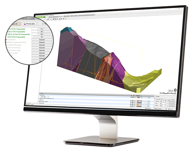
Aumentate la produttività della modellazione 3D del sottosuolo con la creazione e l’aggiornamento rapido dei modelli geologici. Quando vengono inseriti nuovi dati, i modelli e gli output (come le sezioni trasversali) si aggiornano dinamicamente senza doverli ricreare, risparmiando tempo e denaro.
La modellazione 3D del sottosuolo offre un livello di precisione ed efficienza senza pari nella comprensione delle condizioni del terreno. È possibile identificare e valutare meglio i rischi in ogni fase del ciclo di vita del progetto e individuare tempestivamente i problemi.
Comunicare in modo chiaro
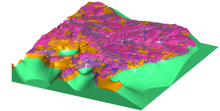
La visione in 3D delle informazioni sul sottosuolo chiarisce anche i dati più complessi, offrendo un livello di comprensione più elevato.
I modelli 3D del sottosuolo, estremamente dettagliati, aiutano a interpretare meglio le condizioni del terreno. Comunicate più chiaramente i rischi a tutte le parti interessate utilizzando gli strumenti di visualizzazione gratuiti, tra cui Seequent View, Leapfrog Viewer e filmati, ed esportate immagini di alta qualità e layout di sezione per relazioni e presentazioni.
Collaborare con tutti i team
Leapfrog Works supporta i formati di dati di indagine del terreno standard del settore. È inoltre possibile combinare i modelli geologici con i progetti ingegneristici, i flussi di lavoro BIM e i modelli di flusso delle acque sotterranee, per avere un quadro completo del progetto.
Collaborate con i geologi quando dovete prendere decisioni critiche sulle condizioni del terreno. Combinate il vostro Modello informativo geologico con i vostri Building Information Models e consentite la collaborazione con altri team per sviluppare un Modello informativo dell’infrastruttura.
Migliorate l’analisi dei dati geoscientifici
Lavorate senza problemi in ambienti GIS e di geoscienza grazie all’integrazione Esri integrata e alla connettività plug-in con MapInfo.

Dynamic 3D modelling
Easily copy and build multiple models to explore various hypotheses and then update them dynamically with your latest information. Automatically add new borehole data while parameters hold true.
Create static models for comparison and reference. Spend less time building models and more time interpreting and sharing.

Ground type classifications
Rapidly build 3D geological and numeric models from a wide variety of data sources including borehole, structural, GIS, 2D grid, map, point, polyline, mesh/surface, historical cross section data, geotechnical investigations, well screens, or points.
Apply an array of modelling methods and powerful intuitive interpolant controls. Perform structural modelling and use borehole planning tools. Combine rock mass ratings, soil behaviour, or contaminant concentrations with geological domains for combined ground type classifications.

Collaboration and sharing
Easily share your cross sections, images and movies, interactive 3D scenes, BIM, and CAD data outputs, not only enhancing productivity but your understanding.
Visualise and share projects rapidly with Central for better workflow and communication, allowing everyone from technical staff to non-technical stakeholders to understand what the data is saying.

Interoperability
Connect directly to Bentley’s OpenGround Cloud platform to access your single source of geotechncial data. Easily import and export geotechnical and geoenvironmental data to specialist software packages, including GIS data from Esri geodatabases and shapefiles, Map Info, or raster images and maps.
Export seamlessly in industry recognised BIM formats and publish directly into the BIM environment. Integrate Drawing eXchange Format (DXF), Civil3D, and AutoCAD Drawing (DWG) formats from Autodesk.

Engineering designs
Don’t wait for the CAD department to process your job, work directly with your engineering data in the geological context model.
Rapidly visualise and understand detailed tunnel, motorway earthworks, bridge, dam and building foundation designs in geological context. Integrate designs, build surface topography, and create excavation volumes to inform design. Import alignments and create longitudinal sections, fast.

Environmental insight
3D geological modelling makes it easy for you to build geology and initial values for groundwater flow simulation.
Rapidly assess contaminant plumes or saltwater intrusion by combing geological models with water sample screens or geophysical data. Model directly from screens in AGS or gINT projects. Visualise plumes or saltwater wedge intrusion in 3D. Then, use the Hydrogeology Solution Kit to easily combine with flow models.

Generate cross sections
Make sections anywhere on site in minutes, not hours. Visualise from any angle, turn, rotate, and rapidly detect errors. Work intuitively with tools that help you advance your analysis and recognise correlations and trends. Update dynamically as the model evolves.
Import historic sections and maps. Tailor outputs for reports, CAD, or geotechnical analysis.

Hydrogeology Extension
Use this optional kit to incorporate MODFLOW and FEFLOW flow models to further reduce your risk. Easily use lithology models as the basis for flow models to visualise modelling results.
Import, create, and assign properties to MODFLOW and FEFLOW grids/meshes from your subsurface model. Visualise grids in a 3D scene and share your models with free tools Leapfrog Viewer and Seequent View.

Contaminants extension
Bring contaminant data directly into your Leapfrog Works 3D geological models. This intuitive, interactive extension allows you to characterise, visualise, and create auditable estimates of contaminant mass and location in land and groundwater environments.
Learn more.
Le novità di Leapfrog Works 2025.1
Leapfrog 2025.1 is a landmark release that introduces a comprehensive overhaul of structural trends, providing faster and more precise trends with exposed clustering controls and improved logic.
In addition, Leapfrog 2025.1 includes several workflow and usability enhancements. Users can now manage polylines more easily with improved attribute persistence and mesh attribute tables and filtering. Stereonet enhancements, including new color maps and layout controls, provide clearer structural analysis.
This release also allows users to communicate more effectively with cross sections. You can now set an orthogonal or illustrative (formerly scaled) projection style on long sections for drillholes, planned drillholes, and polylines. Other improvements include applying query filters to display only part of a polyline and displaying positive or negative offset labels for holes on sections, making it easier to interpret and present section data.
Please ensure you sign out of your current version of the application before attempting to upgrade to the newest version. Once signed out, please follow the standard upgrade path. If you fail to sign out before attempting to upgrade, you may not be able to access the software and your seat will need to be re-issued by Seequent support.
A more complete list of the new features can be found here:
All the new features introduced in the latest version are detailed in the “Release Notes” PDF Brochure:
Estensioni
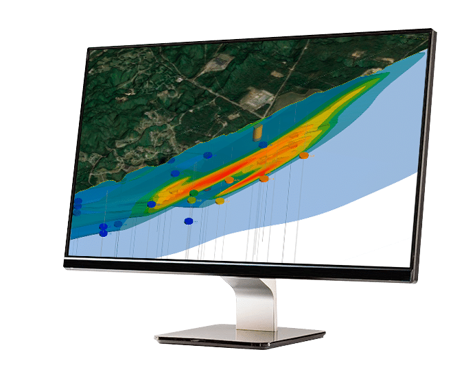
Bring contaminant data into 3D geological models
Conoscere il cumulo. Aggiungete un’estensione intuitiva e interattiva che vi aiuti a creare stime trasparenti e verificabili della massa dei contaminanti.
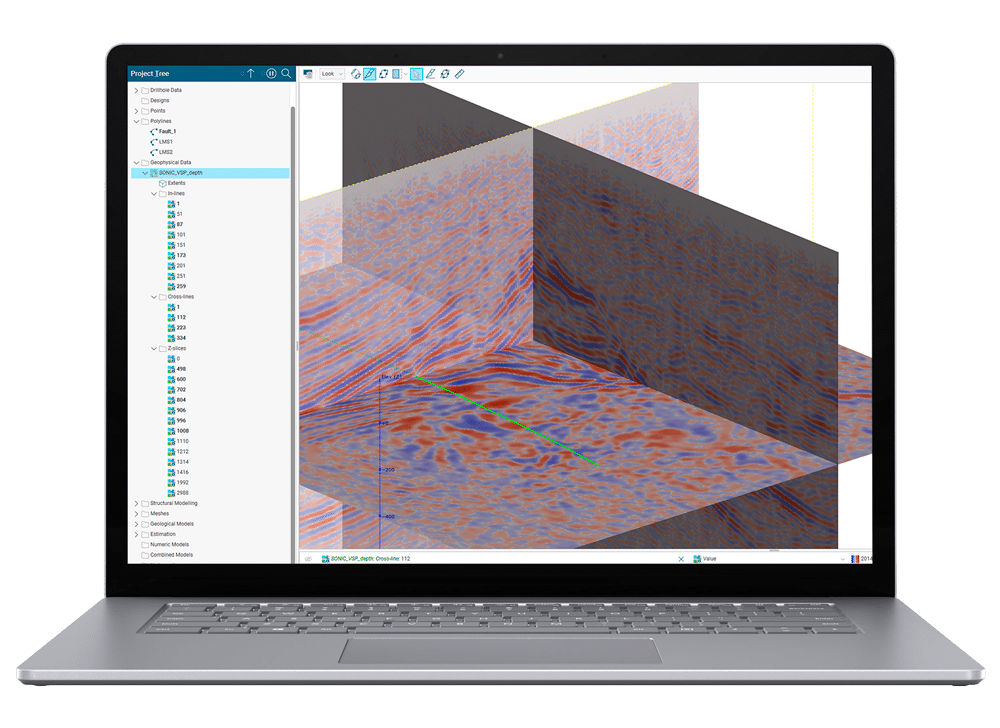
Leverage your Ground Penetrating Rader (GPR) and Seismic data in Leapfrog
Aggiungete l’estensione Geophysics a Leapfrog Works per integrare senza problemi i dati sismici e del Ground Penetrating Radar per guidarne l’interpretazione e visualizzarli nel contesto del modello geologico 3D.
Formati supportati da Leapfrog Works
La lista completa di tutti i tipi di dati e formati supportati da Leapfrog Works per l’Input (Import) e l’Output (Export) è dettagliata e aggiornata sul sito Seequent:
Leapfrog Works Supported Data Types & Formats …
Tipologie di licenza per Leapfrog Works
Leapfrog Works è disponibile in versione Shared (Condivisa) che consente l’utilizzo del software da parte di più utenti della stessa organizzazione, o in versione Named (Nominale/Personale) che consente l’utilizzo SOLO all’utente intestatario della licenza.
I prodotti Leapfrog sono distribuiti solo in licenza con sottoscrizione annuale.
Requisiti di sistema per Leapfrog Works
Sul sito Seequent sono dettagliati per i software Leapfrog i requisiti minimi e quelli consigliati sia per la parte computazionale (Core system Requirements) che per la grafica (Graphics Requirements):
Leapfrog System Requirements …