E’ un pacchetto software unico e completo per l’elaborazione, l’inversione e la visualizzazione di dati geofisici e geologici. Il pacchetto integra tutte le fasi del flusso di lavoro, dalla gestione dei dati grezzi alla visualizzazione e interpretazione finale dei modelli di inversione.
Il pacchetto AGS Workbench comprende moduli di elaborazione dati dedicati per molti tipi di dati geofisici e una piattaforma GIS integrata.
Adalta è Rivenditore Ufficiale e Importatore Diretto per l’Italia di Seequent AGS Workbench. Richiesta quotazione…
Key features
- Supports electrical and electromagnetic data from both airborne and ground-based systems
- Fully developed processing tools and filters
- Support for digital elevation models
- Support for import of borehole lithology and geophysical borehole logs
- Integrated GIS interface with WMTS support for easier processing and visualization
- Visualization of data in themes, sections and 3D.
- Quality control visualization tool
- LCI and SCI inversion with AarhusInv inversion code
- 1D/2D ERT/IP inversion with AarhusInv inversion code
- Full ERT/IP decay inversion with Cole-Cole & Maximum Phase Angle inversion
- TEM IP Cole-Cole & Maximum Phase Angle inversion for modelling of TEM data with IP effects
- Cloud inversion
- 2D/3D gridding
Modules
- Essentials – Basic module for Aarhus Workbench
- Airborne TEM – Support several airborne TEM systems, e.g. SkyTEM, VTEM, TEMPEST etc.
- Airborne TEM IP addon – Maximum Phase Angle and Cole-Cole inversion for data with IP effects.
- Airborne HEM – Supports all coil configurations for airborne HEM systems, e.g. Resolve and DigHEM
- GCM – Supports all coil configurations and all GCM instruments
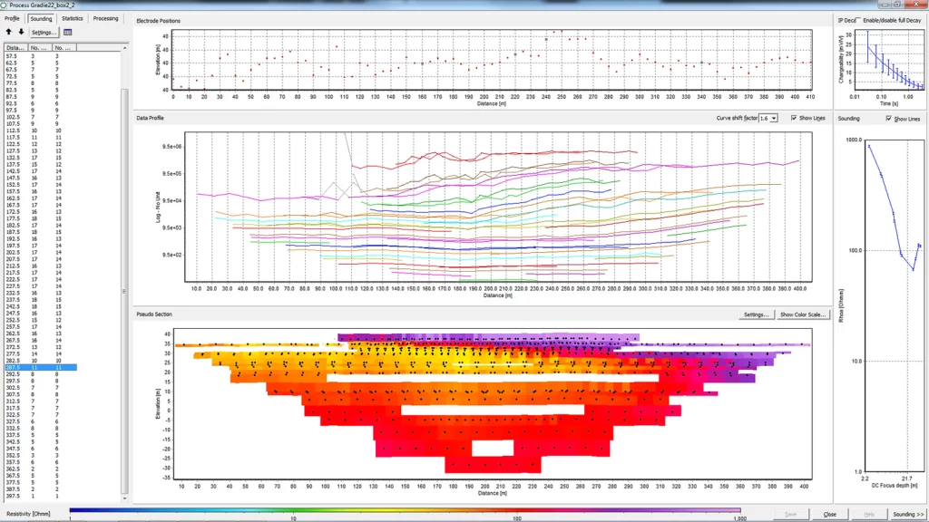
- DC/IP – Full developed processing tool and 1D/2D ERT/IP inversion
- Ground-based towed TEM – For towed TEM systems
- tTEM – special module for the tTEM system
- Streamed ERT – For streamed ERT solutions
Other - Aarhus Batch Inversion Distributed – run inversions on local Servers/PC from local desktop.
- Aarhus Cloud inversion – run high computational demanding inversions in the Cloud
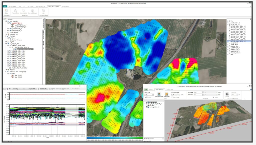
Visualization and interpretation
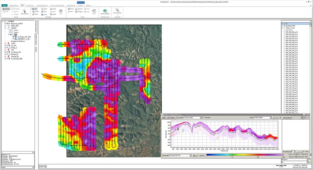
Visualization, evaluation, and geological interpretation of the inversion results is done with the GIS interface, which is integrated with the processing tool and cross sections. Aarhus Workbench is fully compatible with ArcGIS formats (GeoTiff, Shape-files) and Surfer grid file format.
GIS themes
- Creation of geophysical theme maps, e.g. mean resistivity, elevation of geological interfaces, etc.
- Gridding of themes using Kriging or inverse distance interpolation, including semi-variogram analysis.
- Visualization of theme maps as colorized points or grid images.
- Quality check of inversion results with model quality too.
- Borehole locations with easy access to detailed borehole reports.
- External GIS themes in ArcGIS formats (GeoTiff, Shape-files).
Cross sections
- Section location by drawing directly in the GIS-map or based on survey flight lines.
- Resistivity models displayed as bars or interpolated filled sections, combined with depth of investigation (DOI) information.
- Boreholes as bars with easy access to detailed borehole reports.
- Digitization of layer interfaces for easy geological model building.
- Sections combined with intersections in a grid displayed as lines.
- Extended label options for resistivity bars and boreholes; e.g. projection distances, lithology etc.
Presentation
- 3D viewer with tools for cutting/planes and parameter thresholds
- PDF report tool – Create pdf templates and high resolution pdf reports with data and results.
Enriching Subsurface Digital Twins through Electromagnetic Remote Sensing for Water, Environmental, and Infrastructure Resilience.
EXTON, Pa. – July 7, 2021 – Bentley Systems, Incorporated (Nasdaq: BSY), the infrastructure engineering software company, today announced that its Seequent business unit has acquired Danish company Aarhus GeoSoftware, a developer of geophysical software. The acquisition extends Seequent’s solutions for operational ground water management, and for sustainability projects involving exploration, contaminants, and infrastructure resilience.
Aarhus GeoSoftware, a spinoff company from Aarhus University in Denmark, develops the software packages AGS Workbench, SPIA, Res2DInv, and Res3DInv for the processing, inversion, and visualization of geophysical data from ground-based and airborne electromagnetic (EM), electrical resistivity tomography (ERT) remote sensing, and other sources. AGS software enables users to create 2D and 3D images of subsurface electrical resistivity. The outputs of the software can be used to distinguish and differentiate subsurface materials and can subsequently be modeled in Seequent’s Leapfrog to aid in various subsurface investigations.
The software uses electric field measurements, collected at ground level or with airborne sensors, to map the subsurface distribution of certain materials such as water, mineral deposits, and clays. Electrical resistivity allows a better understanding of the distribution of materials such as water, mineral deposits, and clays, and when the water contains other compounds such as salt, researchers and industry professionals can infer the distribution.
The genesis of AGS software was to ensure clean drinking water for future generations by mapping groundwater across Denmark. It is now used in many different areas, including locating subsurface faults and cavities to mitigate construction risk, in mining for investigating orebodies and waste rock and tailing processes, monitoring movements of groundwater and contaminants to help understand environmental impacts, modeling dam and tunnel stability, and assessing landslide risk to gauge asset resilience or construction plan impacts. Seequent will continue its tradition of collaborating with universities and research organizations worldwide through ongoing engagement with Aarhus University for the development of AGS geophysical solutions.
Graham Grant, chief executive officer of Seequent, said, “The acquisition will add new geophysical data processing capabilities to our workflows to help advance subsurface investigation and modeling. AGS software, coupled with Seequent’s advanced geologic modeling and analysis software, creates a key tool in helping understand and manage groundwater and assessing risk in infrastructure such as dams and canals. We’re excited about the new possibilities this opens up for our collective users worldwide, improving life-time digital twins.”
Toke Højbjerg Søltoft, chief executive officer of Aarhus GeoSoftware, said, “Seequent’s global reach will allow AGS software to positively impact more projects worldwide. As we continue to develop solutions, our users will benefit from our tools being in Seequent’s ecosystem and workflow. We’re excited to join Seequent and to work together on our shared vision of helping organizations make more informed and sustainable decisions through a better understanding of the subsurface.”
For more information, please visit https://www.aarhusgeosoftware.dk/
AGS Workbench is a comprehensive software package for processing, inversion, and visualization of geophysical and geological data. The AGS Workbench package is based on a GIS interface and includes dedicated data processing modules for various geophysical data types. The package integrates all workflow steps from processing the raw data to the final visualization and interpretation of the inversion models.
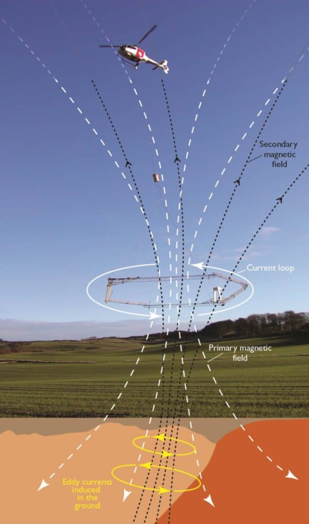
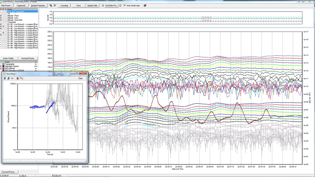
Airborne Electromagnetic (AEM) remote sensing is used to collect extensive volumes of data from an aircraft.
A sensor loop below a helicopter or small plane transmits an electromagnetic signal to the earth.
Based on the subsurface properties, a secondary field is created and measured at the aircraft.
These data are then processed to estimate subsurface electrical properties.
The AGS Workbench software is used for processing, inversion, and visualization of the data collected by AEM and other geophysical methods.
Airborne Electromagnetic (AEM) remote sensing uses electromagnetic induction to collect extensive volumes of data from an aircraft. It is a fast and cost-effective way of subsurface mapping, can cover large areas (10s-1000s of km2) in a few days, requires no new drilling or ground access, and, using 3D modeling and visualization software, has a quick turnaround for mapping the subsurface.
The technique involves a helicopter or a small airplane towing a sensor loop approximately 100 feet (30 meters) above the ground. This generates an electromagnetic signal transmitted into the earth based on the subsurface properties, thereby a secondary field is created and measured at the aircraft. These data are then processed to estimate subsurface electrical properties. Depending on resistivity or conductivity, the returned signal helps geoscientists establish the nature of the subsurface.
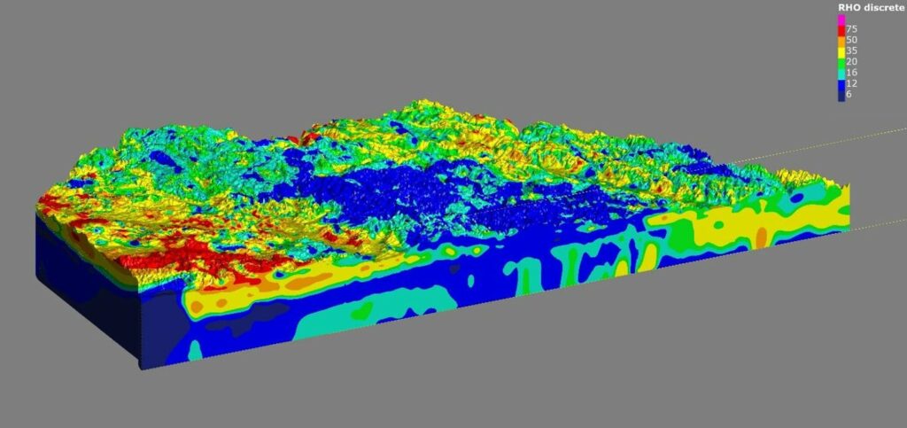
Sensing data processed and inverted in AGS Workbench software can then be combined in Seequent’s Leapfrog Works to create a 3D model that gives a detailed overview of resources. The above image is a hydrogeological map of the subsurface of the Principal Aquifer (and parts of the Ogallala Aquifer) in Nebraska, United States.
Airborne Electromagnetic (AEM) remote sensing was used to capture data from the 4,000-square-mile study area. The color-coded volumes represent eight resistivity categories. Higher resistivity values are represented as yellow to red (sand and gravel), lower resistivity values are represented as blue to green (clay and silt), and brown represents bedrock.
Nuove caratteristiche in AGS Workbench 2026.1
This update helps you organise, review, and deliver survey results with greater clarity and control. Manage large datasets more efficiently, work confidently with new TEM formats, and prepare data for clients or regulators with less effort.
Highlights:
- Improved inversion workflow reduces errors and saves time
- All parameters and notes in one place for transparent decision-making
- Enhanced workspace for faster data review and quality checks
- Flexible tools for splitting, sharing, and managing surveys
- Expanded support for new TEM data types
- Direct Gerda upload for Danish users
These updates are shaped by user feedback and built for teams working across large surveys, phased deliveries, and collaborative interpretation.
A complete list of the new features can be found here:
All the new features introduced in the latest version are detailed in the “Release Notes” PDF Brochure:
Video with new features of AGS Workbench latest version
Brochure AGS Workbench
Download the PDF brochure to conveniently evaluate all the features of the software.
Requisiti di sistema per AGS Workbench
Sul sito Seequent sono dettagliati i Requisiti di Sistema minimi e quelli consigliati per AGS Workbench …
More about AGS Workbench
Want to learn more about all the features of the AGS – Aarhus Workbench?