Eliminare l’incertezza del sottosuolo.
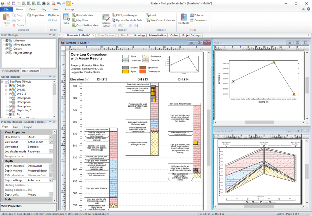
Strater visualizza i tuoi dati grezzi come pozzi e di trivellazione, elenchi di pozzi, mappe e sezioni trasversali.
Strater offre una flessibilità insuperabile nel design e nel layout.
L’intuitiva interfaccia utente point-and-click di Strater rende facile visualizzare rapidamente i dati del sottosuolo e creare rapporti professionali.
Adalta è Rivenditore Ufficiale e Importatore Diretto per l’Italia di Golden Strater. Richiesta quotazione…
NOTA DA GOLDEN
GOLDEN SOFTWARE CONTINUERA’ A SUPPORTARE STRATER, MA NON VERRA’ PIU’ AGGIORNATO.
A cosa serve Strater?
Visualizzare i dati
Eliminare l’incertezza del sottosuolo. Ottenete una maggiore comprensione e chiarezza trasformando i dati grezzi del sottosuolo in log di pozzo, modelli di foro e sezioni trasversali/profili comprensibili. Create facilmente relazioni geotecniche professionali che comunichino chiaramente le informazioni importanti con Strater.
Analizzare i dati
Ottenete risposte a tutte le vostre domande sul sottosuolo. Quando vengono visualizzati in Strater, i dati del sottosuolo diventano chiari e facili da capire. Le ampie funzionalità di Strater consentono di visualizzare e analizzare rapidamente aree altrimenti invisibili e di prendere decisioni in tutta tranquillità.
Comunicare i risultati
Trasformare i dati in profitto. Comunicare facilmente informazioni importanti a clienti, stakeholder e colleghi. Indipendentemente dalla complessità dei dati, le capacità di visualizzazione di Strater facilitano una comprensione completa e approfondita dei dati del sottosuolo.
Soluzione affidabile
Strater è apprezzato da molti scienziati e ingegneri in tutto il mondo. Provate voi stessi Strater e scoprite perché molti altri si affidano a Strater per la visualizzazione dei loro dati.
Strater viene utilizzato regolarmente nei seguenti settori:
- Education
- Energy
- Environmental
- Exploration
- Geophysical
- Geotechnical
- Geothermal
- Government
- Military
- Mining
- Mudlogging
- Oil & gas
- Utilities
- Water Resources
- And More
Caratteristiche generali di Strater
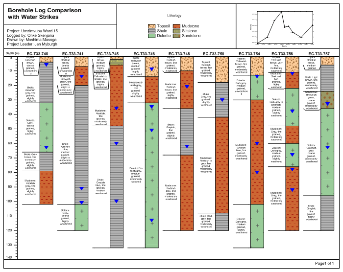
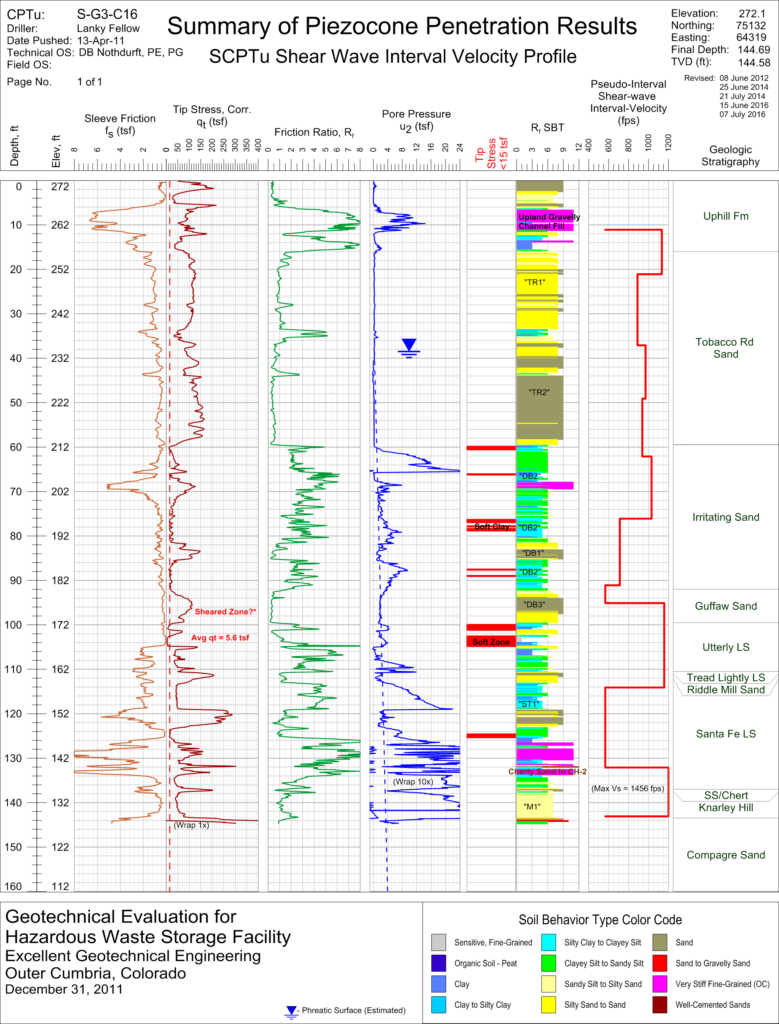
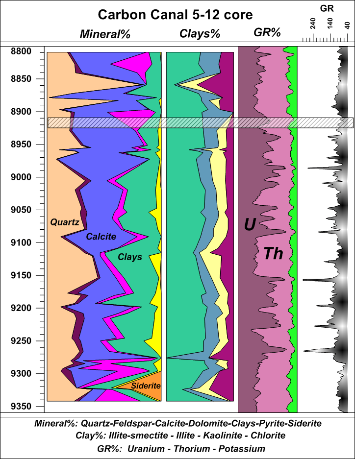
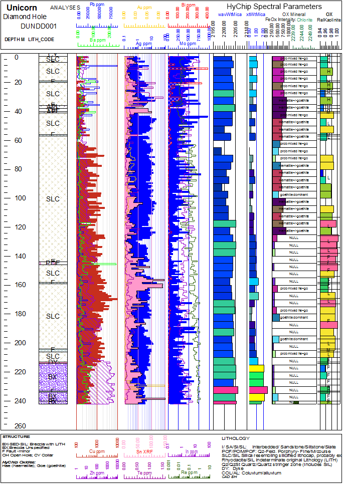
Create Professional Well Logs and Borehole Models
Scoprite la profondità dei vostri dati. Strater trasforma i dati del sottosuolo in log di pozzo e modelli di foro comprensibili. Ottenete una migliore comprensione dei vostri dati in modo da poter prendere decisioni informate, ogni volta.
Strater Log Types
- Depth
- Line/Symbol
- Crossplot
- Function
- Lithology
- Zone Bar
- Bar
- Percentage
- Post
- Classed Post
- Graphic
- Complex Text
- Well Construction
- Raster
- Graphic
- Tadpole
Subsurface Data Made Clear
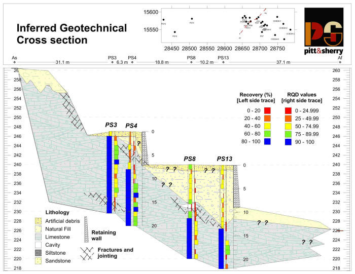
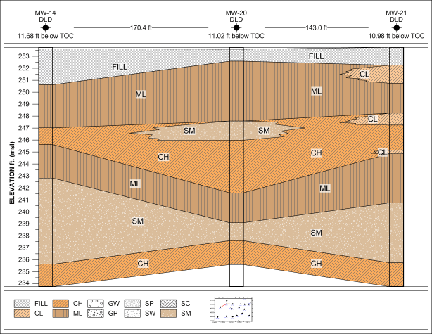
Evaluate and display all aspects of geological data. Easily create cross sections from lithology/zone bar logs, line/symbol logs, or raster logs to better understand the details of your depth data. Maximize your understanding so you can make the best decisions, every time.
Enhance Your Geological Model
Represent your data at its best. Precisely display subsurface data with Strater’s numerous customization options. Virtually every aspect of Strater’s logs, models, and cross sections are customizable.
Strater Customization Options
- Include titles, axes, scale bars, and legends
- Apply pre-defined or custom fill patterns based on industry standards
- Generate custom fill libraries to be shared with colleagues and reused across multiple projects
- Include customized headers and footers
- Draw text, polylines, polygons, symbols, and spline polylines
- Utilize tools to align, overlay, or distribute logs as needed
- Create standardized templates to create consistent reports
Strater Cross Section Customization Options
- Add any type of log to an existing cross section
- Display logs as deviated or vertical
- Display water level(s) in the cross section
- Add well headers to display borehole information, as well as distance between well tops or bottoms
- Define and customize lithology/stratigraphy layers
- Use schemes to quickly apply symbol, fill, and line properties and save them for use across multiple projects
- Transform cross sections into 3D fence diagrams with the Voxler integration commands
- Hang logs at the proper elevation
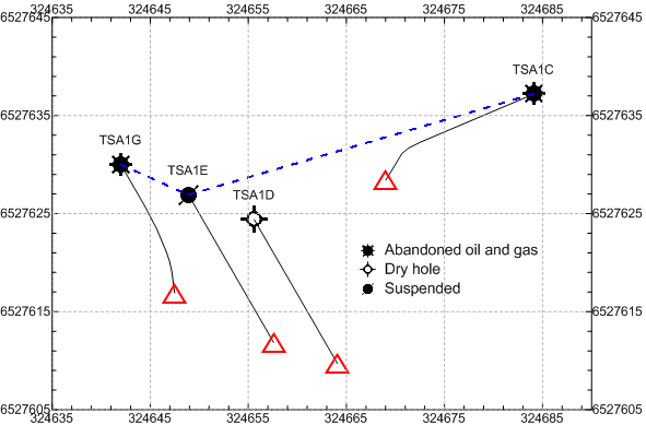
Top-Down View
Create top-down maps to view well log and borehole information in the correct geographic context.
Strater Map View Features
- Insert map view into both borehole views and cross section views
- Post well locations, add boundary information, and include image base maps
- Show borehole deviation paths
- Easily combine maps from various coordinate systems
- Use schemes to quickly apply symbol, fill, and line properties and save them for use across multiple projects
- Add labels from well data
- Draw text, polylines, polygons, symbols, and spline polylines to create features and annotations
- Include and edit axis ticks, labels, and grid lines
Streamlined Workflows
Increase productivity. Quickly create informative and useful models with Strater’s intuitive user interface. Thereafter, easily view all project information with the dynamic graphical display where you can see boreholes, maps, and cross sections in a single project.
Strater User Interface Features
- Single window to view, edit, and manipulate logs and models
- Object manager to easily manage logs, cross section components, and map layers
- Property manager for quick feature editing
- View manager to customize the display of boreholes, maps, and cross sections
- Table manager to view or edit raw data
- Dock or float and hide or display all managers
- Welcome dialog to get you started
- Customize practically all aspects of the user interface to fit your needs
Cosa c’è di nuovo in Strater?
L’ultima versione di Strater presenta diverse novità!
Le principali novità sono elencate di seguito.
A more complete list of the new features can be found here:
Requisiti di sistema di Strater
Con il rilascio di Strater 5.5 e le nuove opzioni di licenza, i requisiti di sistema di Strater sono cambiati.
The system requirements for Strater 5.5 and newer are:
- Windows 7, 8 (excluding RT), 10 or higher
- 32-bit and 64-bit operation system support
- 1024 x 768 or higher monitor resolution with minimum 16-bit color depth
- At least 500 MB free hard disk space
- At least 512 MB RAM
The system requirements for Strater 5.4 and older are:
- Windows XP SP2 or higher, Vista, 7, 8 (excluding RT), 10 or higher
- 32-bit and 64-bit operation system support
- 1024 x 768 or higher monitor resolution with minimum 16-bit color depth
- At least 500 MB free hard disk space
- At least 512 MB RAM